Purpose
The Community of Branch has a wealth of cultural resourses that enriches the lives of its residents and entices visitors to linger. In order to understand its cultural resources, Branch, together with its partners, is beginning to develop tools such as Cultural Resource Mapping to leverage this wealth. The collection and mapping of cultural resources can then be integrated across all areas of municipal planning and decision-making. This site takes into account intangible assets such as values, stories, customs and traditions and natural areas that define the identity of Branch. It also accounts for the tangible assets such as spaces and facilities, cultural organizations, cultural occupations and cultural industries.
About the Community of Branch
Branch is located in St. Mary's Bay on the southwest tip of the Avalon Peninsula of Newfoundland - Canada's most eastern province. Branch was first settled in the 1790s by Irish immigrants lured to this part of the New World by teeming fish in the waters around the Grand Banks and Cape St. Mary's.
Thomas Nash and his family first settled Branch in the late eighteenth century. Nash immigrated from Callan, County Kilkenny, Ireland in 1765 and lived in Capelin Cove - present day Calvert on Newfoundland's Southern Shore. He permanently moved to Branch in the 1790s and built a homestead around summer fishing accommodations he had already built. Nash fished in the summertime while clearing land, tilling the soil, growing vegetables, raising livestock, catching salmon and hunting wild game. He traded fish and excess produce for living supplies not available in Branch.
Branch Statistical Information
- Population, 2011: 245
- Private Dwellings, 2011: 170
- Land Area: 16 square kilometers
- Source: Census 2011: Population by Age and Gender and Dwellings, Community Accounts
Other Statistical Resources
About Cultural Resource Mapping
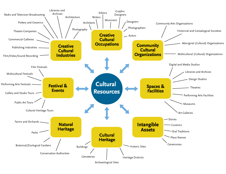 Cultural Resource Mapping is a systematic approach to identifying, recording and classifying a community's cultural resources in order to describe and visualize them. (Cultural Resource Mapping: A Guide for Municipalities)
Cultural Framework and context courtesy of MappingAuthenticity.com
- Help tourists locate pieces that have interest to them, as well as other points found nearby
- Archive areas that have held cultural significance in the community for future generations
- Develop tours with people in the community that link pieces of information that are part of a story
For an example of Google Mapping try the Cultural Heritage page for Branch.
- Help visitors identify locations or landmarks
- Archive areas that have held cultural significance in the community for future generations
- If the images carry over an extended time frame, they can help show the changes in the landmark as well as the surrounding community
For an example of an Image Gallery, view the listing for Adrian Power's Hearth.
Video and Audio can be added for each piece of information to help fill in the cultural context. For example, this video is related to the poem/story excerpt Branch in a July Sun.
For an example of a Story, view "A True Branch Man" by Mallary McGrath in the Intangible Assets section.